Kayaking to the Manukau Heads
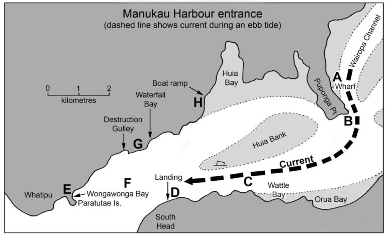
In past years the Auckland Canoe Club has organized many trips out to South Head, at the entrance to the Manukau Harbour. This area has a bad reputation, and many paddlers would perhaps not think of going there; but if light winds are forecast the trip usually turns out to be relatively easy and well within the reach of intermediate paddlers. Once out at South Head or Whatipu, there are opportunities for coastal walks, or a picnic with grand views out across the breakers of the Manukau Bar. Here are some notes based on our past experience, which might be helpful to others. Letters A – H refer to points on the map, (which shows the harbour during an ebb tide). Photographs were taken at various times during the past 20 years.
Author, Colin Quilter
A The usual start-point is at Cornwallis Wharf. There is a boat ramp, parking and toilets. Choose your day and time carefully! Most trips on the Manukau are timed to coincide with high tide; this one is the opposite, and you should aim to reach South Head at low tide. In that case the ebb tide will carry you out, and the flood tide will bring you home. The distance out to South Head is about 8km, which (with tidal assistance) will take less than an hour to paddle.
B Puponga Point. This peninsula deflects the tidal flow. The outgoing tidal stream runs down the eastern side of the peninsula, then flows southward like a river (dashed line) across the main body of the harbour towards Orua Bay. The stream of fast-moving water is easy to recognize because it is a narrow lane of rough water, with calm (slow-moving) water on each side. If you want a quick trip, stay in the fast lane! This short section across the harbour will probably be the roughest part; once you are across in the shelter of the hills backing Orua and Wattle Bays, conditions will be much calmer.
C In the main channel, heading west, with the Huia Bank (invisible, about 4-7m depth) forming the northern edge of the channel. In this part of the channel (according to the marine chart) the current runs at 3.5 knots (6.5km/hr) at mid-ebb on a spring tide, and 1.6 knots (3km/hr) at neaps. I don’t know of any other place around Auckland or Northland where the tidal stream is as swift as it is here. On our club trips we usually cruise at about 3.5 knots, so a kayaker paddling with this current (at springs) would travel at twice the normal speed; and a kayaker meeting the current head-on would be brought to a stand-still.
One story will illustrate the speed of the current. The western end of the Huia Bank is marked by a red (port-hand) can buoy, (shown on the map). With several knots of current running, this buoy will have a foaming bow-wave like a ship, and a V-shaped wake streaming behind it. On a trip many years ago, we were paddling westwards towards South Head, and approaching the buoy at a closing speed of perhaps 5 knots. I warned Rona, who was paddling alongside me, “Be careful or that buoy will run you over.” She looked at me as though I was crazy, but then realized that the big metal can was racing towards us with an audible rumble from its breaking bow wave. We dodged to one side just in time.
(A note about tides on the Manukau Harbour. Spring tides occur at fortnightly intervals, at the time of full and new moon. At those times, high water always occurs at or near mid-day and midnight. Neap tides occur when the moon is in its first quarter or third quarter, and high water will always occur at or near 6am and 6pm. To visit the Manukau Heads you will probably choose a day when high tide occurs at about 6am, because you want low tide to occur at mid-day when you are at the harbour entrance. In that case your trip will coincide with neap tides, and the ebb and flood tidal streams will only flow at about half the rate which they attain at springs. Don’t worry, they will be fast enough)!
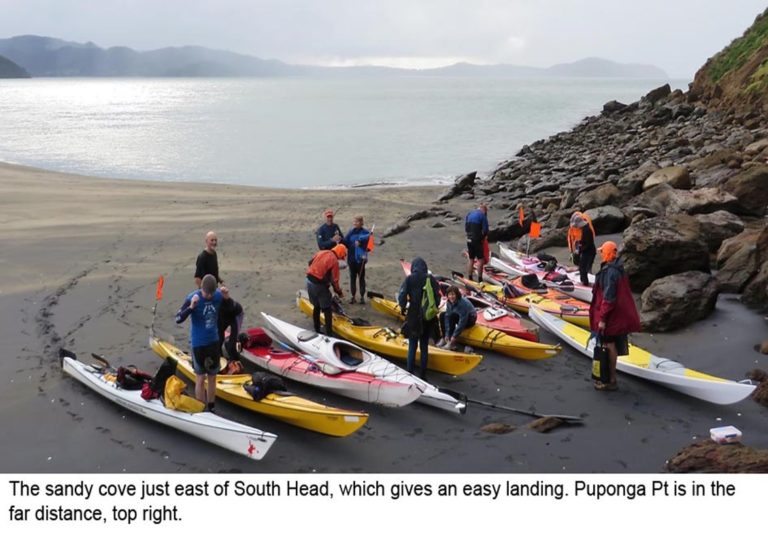
D The landing spot below South Head. Although not marked on a map, this little sandy cove is a constant feature, and always gives a sheltered landing. Don’t get swept past it by the current!
Once ashore, several options are possible. In past years we have usually scrambled up a track which leads steeply up towards the South Head lighthouse. There’s a picnic spot on a grassy ledge half-way up with sun, protection from the wind, and a wonderful view out across the breakers of the Manukau Bar; (however in June 2014 we found the bottom section of the track washed away due to recent erosion, and had to settle for a picnic spot much lower down). If you can reach the top of the hill, it is possible to walk southwest along the cliff-edge for a kilometer or so, with great views. You can then regain the beach by a steep descent to the west which involves jumping a small but vertical drop (“Rona’s Leap”) part-way down. Walking back along the beach will return you to the kayaks. I would allow about 3 hours for lunch plus the walk, so you would need to reach the landing cove about 1.5hr before low tide, and plan to leave it 1.5hr after low tide.
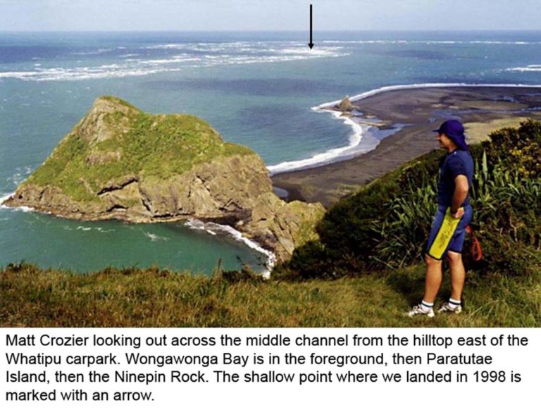
E Wongawonga Bay, near Whatipu. An alternative destination at the harbour entrance. The bay is named after the steamer Wongawonga, which played a part in rescuing survivors of the Orpheus shipwreck in 1863. The bay is sheltered by Paratutae Island, (now joined to the mainland by a sandy spit, and no longer an island). Take care landing here. The bay is always deceptively tranquil, but small swells surge onto the sand with some force. It’s easy to take an unexpected swim when landing or launching. Once ashore you can follow the path (10 min.) towards the carpark behind the beach, then another track (30 min.) which climbs a hill east of the carpark for wide views towards South Head, and out across the bar.
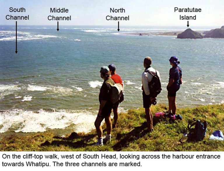
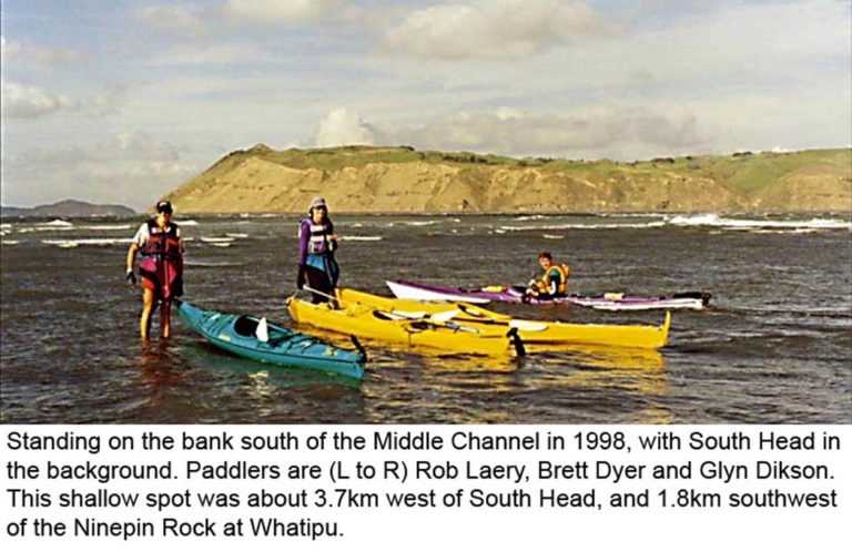
Seaward of Paratutae Island there be dragons. The main shipping channel (Middle Deep) leads due west, with breaking banks along its southern edge. In 1998, on a spring low tide in calm weather, four of us landed on the shallowest part of these banks, out in the ocean 3.7km west of South Head. The banks never dry; we found ourselves standing in shallow water with waves approaching from both sides. The so-called North Channel which swings around to follow the beach north towards Karekare is impassable; its northern end is always closed off by surf.
F The main channel. Conditions here vary with the state of tide. On an outgoing tide the main channel will be calm, (assuming there is no wind). However when the tide turns and begins to run inwards, then the main channel can get suddenly, and dramatically, rougher. If you compare the channel to a river, the explanation is obvious. The Manukau Bar, several kilometers to the west, acts like shallow rapids in a river. Upstream of rapids a river is always calm; downstream of rapids it is rough. A kayaker in the main channel between South Head and Whatipu is upstream of the “rapids” during an outgoing tide, and downstream of the “rapids” during an incoming tide.
So you should expect the main channel to be rougher during the return trip from South Head to Cornwallis than it was during the outward leg. But this will seldom be a problem, because there is usually some wind from the southwest, blowing in the same direction as the current, and this will minimize the sea state.
G Destruction Gulley and Waterfall Bay. Worth visiting to spot seals hauled out on the rocks, but no easy landing at either place.
H Little Huia, where there is a beach and boat ramp. An alternative launching point for a trip to the harbour entrance. If, with an outgoing tide, you want to cross the harbour from here to the cove below South Head, make sure to allow for the distance the tidal current will carry you westward, as you cross. Don’t get carried beyond the cove and out to sea through the South Channel!
That ends our Guide to the Manukau Heads. Go out there and enjoy!
Get in touch
For specific enquiries, contact the relevant committee member/s on the list below.
Written correspondence
P.O. Box 9271 Newmarket, Auckland.