Kayaking destinations around Auckland
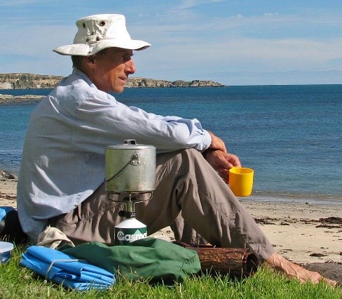
It is widely accepted that the best thing about kayaking is stopping for a cup of tea. If the trip is with friends then there’s the pleasure of discussing good books, recent movies, world affairs and the nature of the universe (in that order of importance); if it’s alone then there’s the pleasure of silent contemplation while waves lap on the shore and gulls wait patiently for a fragment of muesli bar.
Beaches suitable for a cup of tea share certain characteristics. They offer shade in summer but get the sun in the winter. They are protected from the wind. They are never crowded, so they are certainly not accessible by car and preferably not on foot. They should be not too close to one’s launching point, nor too far; it’s nice to paddle for an hour or so before stopping for tea. Is there a better way of spending a morning?
There’s no shortage of cup-of-tea beaches in Auckland. But they are not obvious; in fact the best ones are hard to find, hidden away in forgotten corners of the harbour, un-noticed by impatient folk in a hurry to get somewhere else. Here are a few of my favourites, (compiled from articles published in the ACC newsletter during 2012).
Author, Colin Quilter
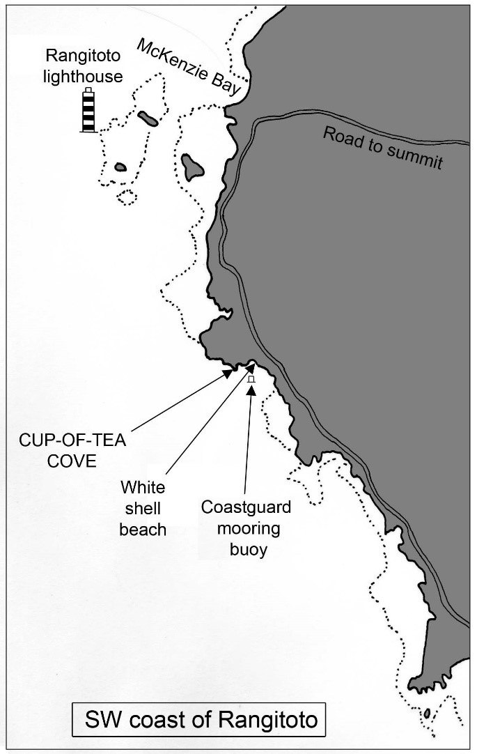
Cove in Coastguard Bay, on the west coast of Rangitoto
Where to go. This cove is hidden on the shore of the Rangitoto Channel. It’s easy to miss, so pay attention to directions! You won’t see this little place until you are right beside it. Let’s assume you are paddling out from one of the Tamaki Drive beaches such as Kohimarama. You will head north towards the Rangitoto Channel. If the tidal current is outgoing (running in your favour), then you will probably stay well out in the channel, near the shipping lane, to gain the best of the current. If the tide is incoming, (running against you), then you will cross to the south coast of Rangitoto (near the gull colony) and from there head NW staying close to the shore to keep out of the current. About 1.5km south of Rangitoto Lighthouse you will reach Coastguard Bay, (more an indentation in the rocky coast than a bay), with an orange mooring buoy. Coastguard Bay has several small white-shell beaches which are conspicuous. Keep going past the mooring buoy and the shell beaches.
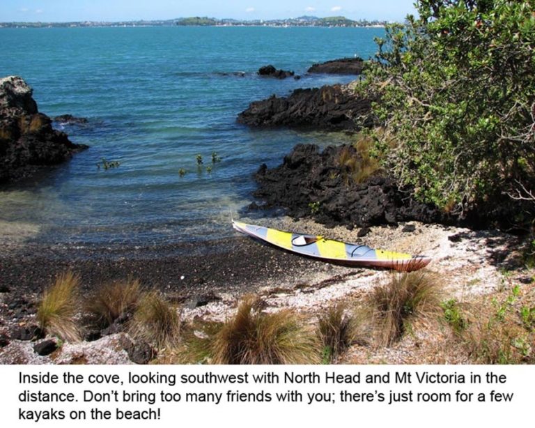
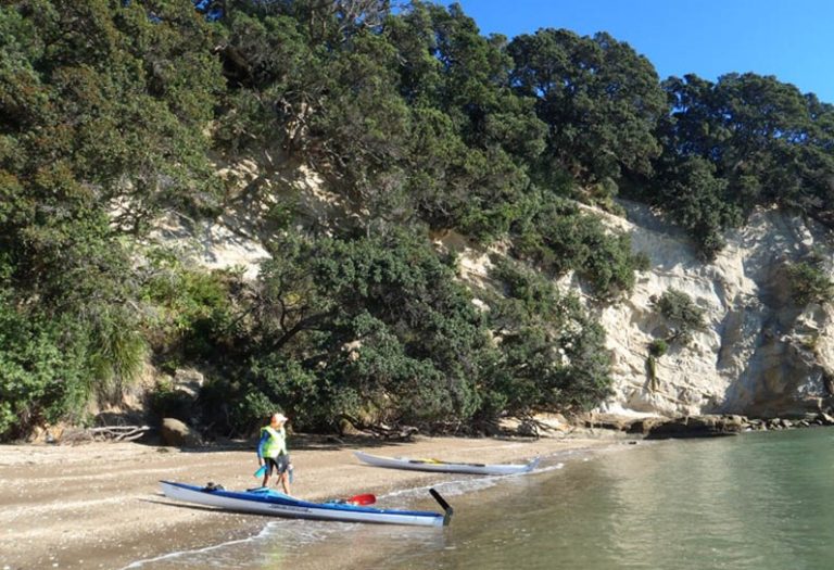
Now there’s a small headland, just a corner really, as you leave Coastguard Bay; and right on that corner is a tiny semicircular cove with a shell beach. The cove is protected from all winds except S and SW. There’s shade beneath a pohutukawa at one end.
When to go. Only at high tide plus or minus two hours! At low tide a barrier of rocks makes access to the cove impossible. However if you misjudge the tide then you can use one of the white shell beaches in Coastguard Bay, which also give easy access to the road for a walk to the summit.
The cove is an excellent destination when northerly winds are forecast. In these conditions McKenzie Bay, just to the north, will be rough and windy but our little cove will be perfectly calm. Moreover, you will have an easy run back to the city with a following wind.
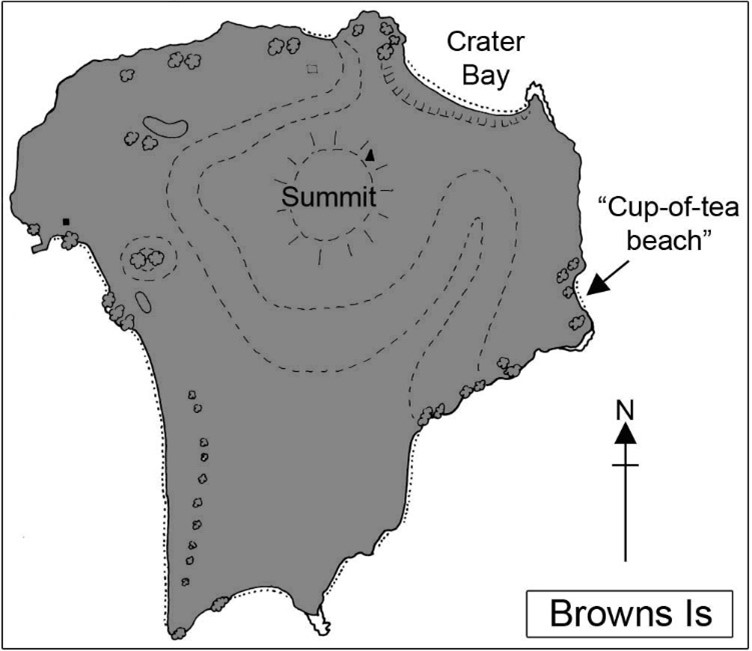
Beach on the eastern side of Browns Is.
Where to go. This little beach is one of my favourites. It is just a nice distance if starting from St Heliers or Kohimarama, it gets the morning sun, and from a comfortable seat on the beach, cup of tea in hand, the city is invisible.
This beach is seldom visited; indeed I can remember only one occasion when I met others there. It was early on a calm Sunday morning and the beach looked empty from a distance. However as I paddled closer I was surprised to see a piece of white fabric come flying out of a patch of long grass behind the beach. It took me a moment or two to realize that it was a bra; and a pair of panties soon followed. I realized that evidently this beach was good for activities other than drinking tea, so I paddled quietly onwards to Crater Bay.
When to go. The beach is sunny and sheltered in SW winds, but is exposed to E winds. It is best at high to mid-tide; there are rocks exposed at low tide. If you arrive at low tide and find it rocky, go around to Crater Bay on the NE corner of the island. Remember that a fresh SW wind (which in Auckland often makes an unwelcome appearance in the late morning) will make the return trip to the city a slog.
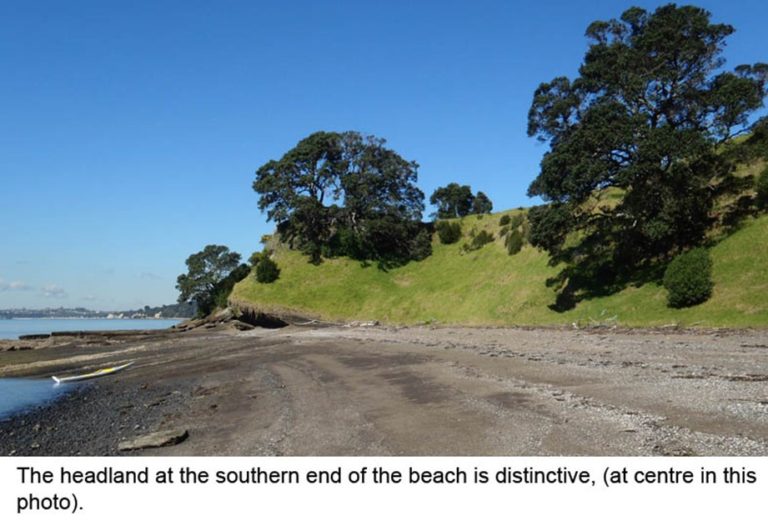
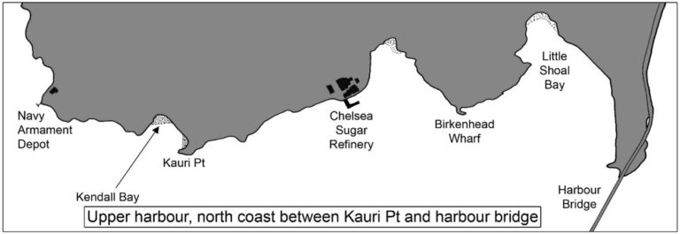
Kendall Bay
This bay was known to Maori as Rongohau (“sheltered from the wind”) and was used as a refuge by canoe parties during northerly gales. It was also used by Maori as a base for shark fishing in the upper Waitemata Harbour, and in the early part of last century was called “Shark Bay” by European families who camped there during summer holidays.
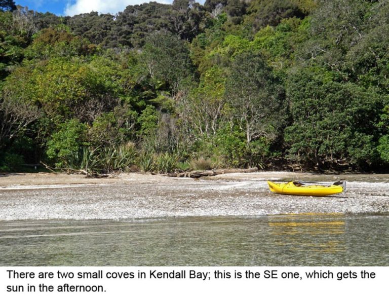
Where to go. On the northern coast of the upper Waitemata Harbour, just west of Kauri Pt. This semicircular cove surrounded by bush actually has two beaches, of which the NW one gets the sun earlier in the day while the SE beach is prettier. Take your pick! There are walking tracks to Kendall Bay, but we won’t disqualify it on that account. The beach is shallow at low tide, but good anytime between mid and high tide. Tidal currents run strongly along the coast between North Head and Kauri Pt; this will influence the timing of the trip.
When to go. Kendall Bay is an excellent destination when northerly winds are forecast; it is well sheltered then, (but windy and cold in southerly winds). If paddling from one of the Tamaki Drive beaches such as Okahu Bay you should launch about 1.5hr before HW; then the flood tide will carry you swiftly up the harbour past Devonport and the city wharves. After a cup of tea you will get assistance from the ebb tide on the return journey. Two easy trips for the price of one!
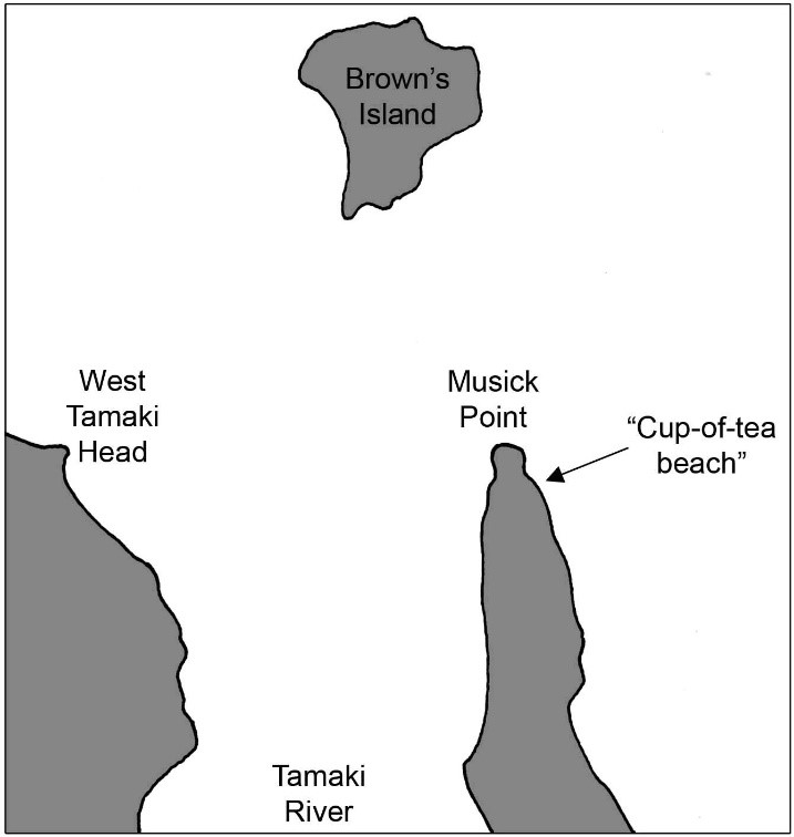
Beach on the eastern side of Musick Point
Where to go. If starting from one of the Tamaki Drive beaches, eg. St Heliers, paddle eastward around Achilles Pt, across the mouth of the Tamaki River, to Musick Point. The headland is named after Captain Edwin Musick, the pilot of a Pan American Airways flying boat who was killed in 1938 when his aircraft crashed in Samoa. On top of the point are Art Deco-style buildings which used to house aviation and maritime radio stations; the buildings are now disused and are maintained by a Heritage Trust. Paddle around the tip of the headland, and about 150 metres south of the tip, on the eastern side, there is a pleasant sandy beach backed by sandstone cliffs and pohutukawa trees.
When to go. The beach gets the sun in the morning, and is perfectly sheltered from southwesterly winds. It is a bit shallow at low tide, but is good anytime between mid and high tides.
This beach offers an alternative to Brown’s Island if you suspect that a rising SW wind might give you a hard slog home from the island.
If launching from Eastern Beach (the closest launch site) remember that Eastern Beach has extensive sand-flats exposed at low tide, which can mean a long carry back to the car. If launching from Bucklands Beach on the western side of the peninsula, you will find that tidal currents run strongly in the Tamaki River.
Cove on Puketutu Island
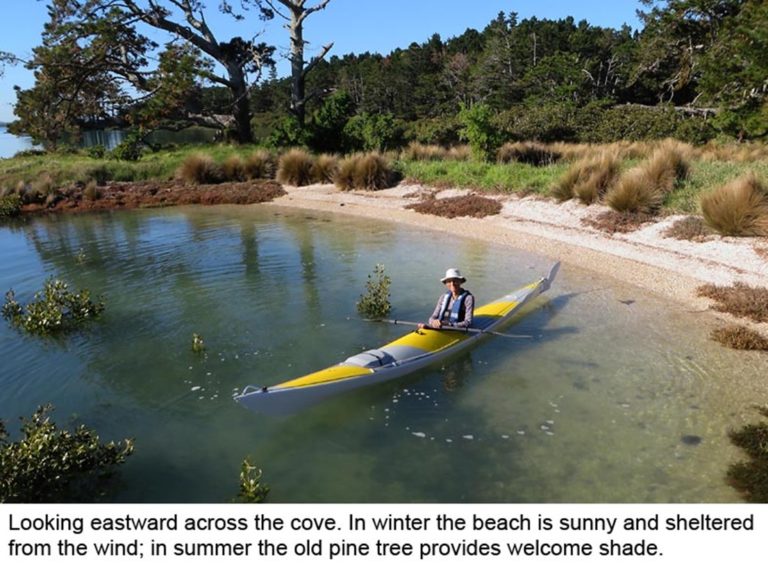
The Manukau Harbour is not a popular kayaking destination, but here’s a charming little beach which is as nice as any you would find on the Waitemata. Despite being within sight of the city it feels remote and secluded; I’ve never met anybody else here.
The cove is on a low-lying promontory on the NW corner of Puketutu Island, (the promontory becomes a small, separate island at high tide). In recent years mangrove bushes have begun to obscure the entrance to the cove, so you won’t see it until you are right alongside.
Where to go.
Here are directions from two alternative start points.
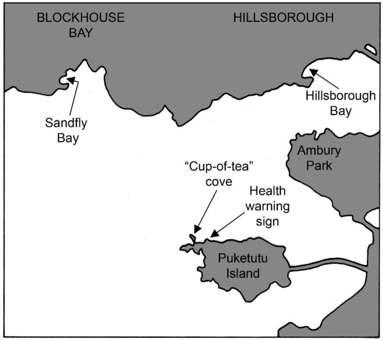
From Hillsborough Bay. There’s a little beach at the foot of Goodall St in Hillsborough, with parking and public toilets. Launch here about 1.5hr before the time of high tide. Head south around White Bluff and across the channel towards Ambury Park. The northern coast of Puketutu Island is straight ahead. Head for the far right-hand corner of Puketutu Island (ie. the NW corner), which has a pine plantation. On a small headland as you near the NW corner there’s a conspicuous Health Warning sign just above water level stating that the harbour may be polluted and you shouldn’t drink it; (which is, of course, why you brought a thermos of tea instead). Three hundred metres past the sign is a low promontory with toitoi bushes and pine trees. Go slowly now! On the near (eastern) side of that promontory, partly hidden by mangrove bushes, is a sheltered north-facing cove with a white-shell beach.
From Sandfly Bay. At the bottom of Endeavour St in Blockhouse Bay is a foreshore reserve with a boat ramp and parking. Launch here about 1.5hr before HW. Paddle SE across the harbour towards the pine forest on the western (right-hand) end of Puketutu Island. As you get closer there are some conspicuous toitoi bushes which show up white against the dark pines. Head for the eastern (left-hand) end of the toitoi bushes. You’ll come to the end of a low basalt shelf (actually a small island); look for our little cove partly hidden by mangroves on the eastern side of the island.
When to go.
As with all trips on the Manukau, it’s essential to consult the tide tables. The journey is about 5km one-way from either of the start points, so you will want to leave about 1.5hr before HW, and you’ll come back to the car-park about 1.5hr after HW. If you go on a day when a SW wind is forecast, then Hillsborough Bay is a good start-point because you will have an easy run home even if the wind gets very strong. Enjoy!
Watchman Island
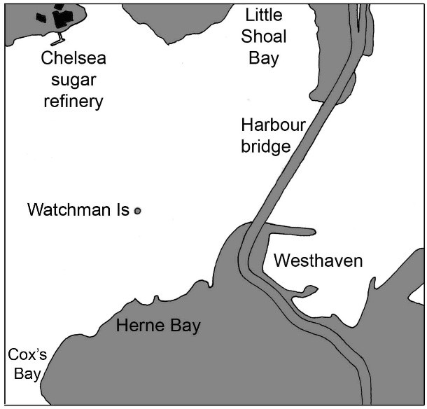
Watchman Island, about 600 metres off the Herne Bay coast, must once have been larger but wind and waves are fast wearing it away. On early British Admiralty charts of the Waitemata Harbour the island is called “Sentinel Rock.”
Where to go. From any of the Tamaki Drive beaches, head west up-harbour past Devonport and the city wharves, beneath the harbour bridge, and there’s little Watchman Island offshore from Herne Bay. The landing is onto a tiny shell beach on the N end; at HW very little of this beach remains, with room for just a few kayaks. A smooth rocky shelf nearby makes a comfortable seat in the sun, with shelter from the wind.
When to go. This is an excellent destination on those mornings (common in Auckland) when a SW wind is forecast to freshen by afternoon. You won’t want to go out to Browns Island or Rangitoto because of the difficulty of slogging home against the wind. However if you can get up to Watchman Island while the wind is light, you are guaranteed an easy return trip even if the wind rises. If HW is mid to late morning, so much the better. The flood tide will carry you up-harbour to Watchman Island, and the ebb will hurry you home. What’s not to enjoy?
If the wind is northerly, then Watchman Island offers no shelter for a cup of tea, and nearby Kendall Bay (on the north shore of the upper harbour near Kauri Pt) is a better destination.
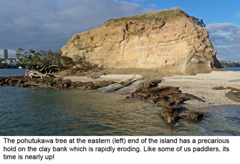
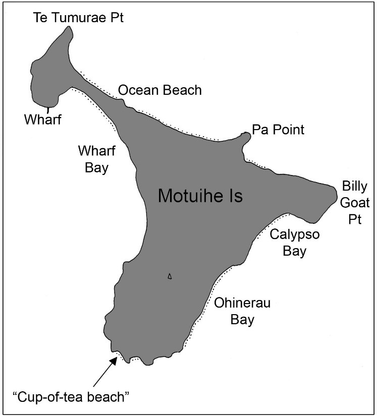
Bay on the SW corner of Motuihe Island
It is said that Auckland is the “City of Sails.” And on fine summer weekends it seems that every sailor heads for Motuihe Island. At the northern end, in Wharf Bay or Ocean Beach, the yachts and launches will be anchored so closely that you could just about cross the bay by jumping from deck to deck. There will be a hubub of noise from generators, stereos, outboard motors and jet-skis, (the sound of Aucklanders “getting away from it all”).
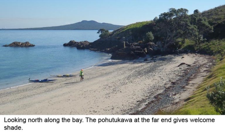
Meanwhile, at the southern end of the island is a tranquil beach with white sand and clear water; an empty beach on which yours might be the only footprints. It will be empty because there is deep water offshore, and strong currents, and therefore no anchorage for boaties. But for a kayaker seeking somewhere for a cup of tea, a swim, and quiet contemplation, it is perfect.
Where to go.
If leaving from St Heliers Bay, paddle eastward passing north or south of Browns Island. Then in the distance, at the southern end of Motuihe you will see a conspicuous white-sand beach (actually made of shell fragments). There’s an equally attractive bay just around the corner to
When to go.
This bay is nice at any state of tide. It has just one disadvantage, and it is a significant one. If a southwesterly wind freshens during mid-morning, as it sometimes does, the trip back to St Heliers will be an 8km struggle into the teeth of the wind. Don’t come here if SW winds are forecast! On the other hand, if a NE sea breeze is predicted then you can paddle out to Motuihe in the early-morning calm, and after a cup of tea race home with the wind at your back.the south-east; take your pick.
Get in touch
For specific enquiries, contact the relevant committee member/s on the list below.
Written correspondence
P.O. Box 9271 Newmarket, Auckland.