Guide to Port Pegasus, Stewart Island
Port Pegasus, near the southern tip of Stewart Island, has all the qualities that kayakers might seek for a paddling holiday. It is on a remote and exposed coast, and yet it is also well protected and encloses a complex of inlets and hidden passages which might take a week to explore fully. In February 2010 I spent six days there. I tried to visit most parts of the harbour, and took notes of campsites and places of interest. These might be helpful to others planning a trip.
I expected that given its many sheltered arms, Port Pegasus would have numerous beaches and campsites; but that’s not the case. The harbour is an ancient valley which has been drowned by the sea, so the bush-clad slopes which come down to the water are actually old ridges and hilltops. They are often steeply-sloping, and there is little flat land close to the water. Perhaps for the same reason, many of the white-sand beaches in Port Pegasus are only beaches at mid and low tides. At high tide the sand is completely covered, and the water laps at the rocks and bush at the back of the beach. However even if you cannot find a beach to land on, waves in the harbour are so small that it’s usually possible to haul ashore on a rocky shelf, or at the mouth of a creek.
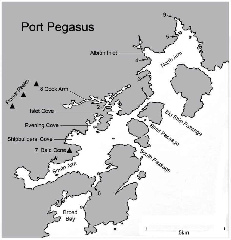
In the notes that follow, numbers refer to the numbered places on the map.
Huts. There are two hunters’ huts. Both are administered by DOC. The charge for their use is $20 per person per booking (the cost is the same whether you stay one or several nights). They are basic 8-bunk huts in excellent condition with the usual facilities (a potbelly stove, tank water off the roof, etc). Hunters have priority in booking the huts, but if they have not been booked then recreational users are welcome. Entries in the hut books suggest that perhaps 10 parties visit each hut per year, so they are not heavily used. Because of the expense of reaching Port Pegasus (by charter boat from Oban or Bluff), hunters usually form groups which will fill the hut, so that the cost of transport is shared among 6 or 8 people. Having planned the trip many months ahead and paid a great deal of money to get there, they will expect exclusive use of the hut, and rightly so. Kayakers using one of the huts as a base should bring an axe and/or saw because the stove will accept only very short pieces of wood.
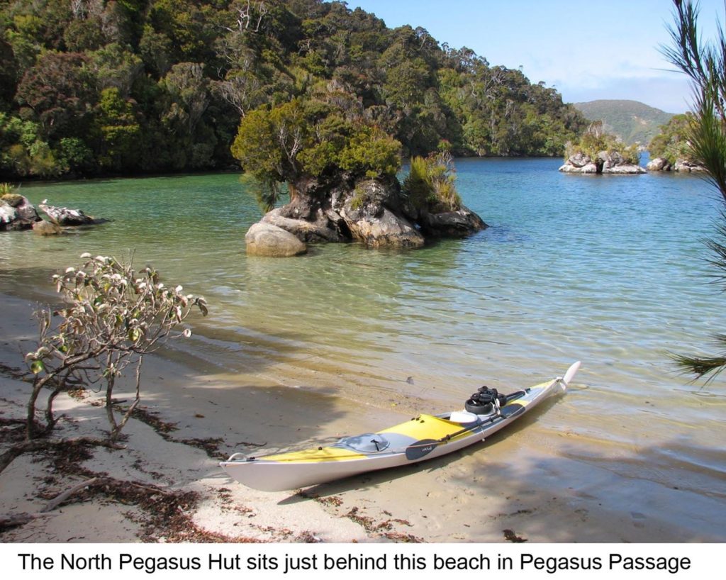
North Pegasus Hunters’ Hut (1). Beautifully sited on a sheltered and sunny beach in Pegasus Passage. A good base to explore the harbour both north and south of the hut. One minute up the track behind the hut there are two beautiful campsites, in the shade of big rimu trees. There’s another on a grassy flat alongside the hut, but it might be prone to flooding. A hunter’s track leads westward up the spur behind the hut; after 30min you will reach a flat summit where weather forecasts can be received on VHF Channel 23 (see later). In my view this is a great advantage of the North Pegasus Hut.
South Pegasus Hunters’ Hut (2). On the western shore of Islet Cove, on a small plateau just north of the beach (and not easily seen from the water). Look for a couple of stakes set into the sand on the beach, and fishing boat moorings in the bay. There are two good campsites between the hut and the beach.
Bulling Bay (3). This is a nice white-sand beach facing NE. There are 2 or 3 campsites, shaded by trees, on the grassy flat behind the beach. I looked for campsites in Ben’s Bay and Red Beach on either side of Bulling Bay, but couldn’t find anything.
An un-named cove in the entrance to Albion Inlet, on the south side (4). The beach is pleasant and north-facing. There are two campsites on the flat behind the beach, with shade and water.
Twilight Bay (5), on the south side of a small peninsula which is just south of Rosa Island. The beach faces east and will get the morning sun; there are two campsites with shade and water.
Disappointment Cove (6). There’s a track which leads from here across the isthmus to Broad Bay (10min). Two campsites have been established here by hunters, but the place is rather gloomy, and the landing is more like the mouth of a creek than a beach.
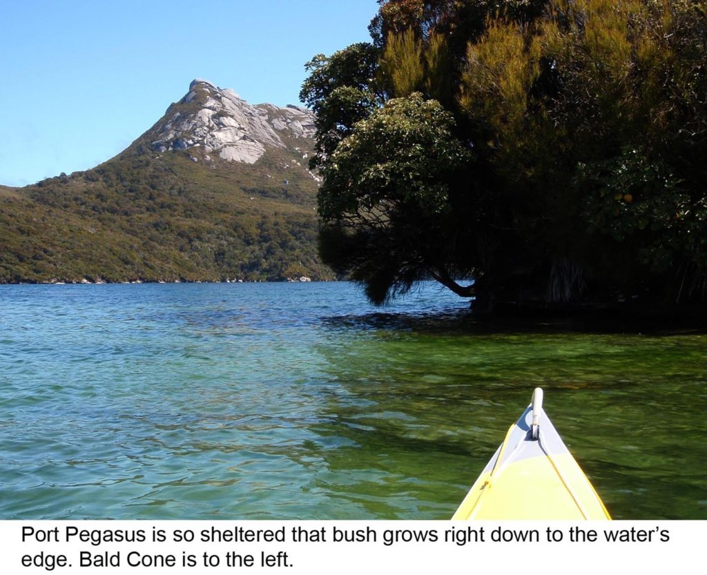
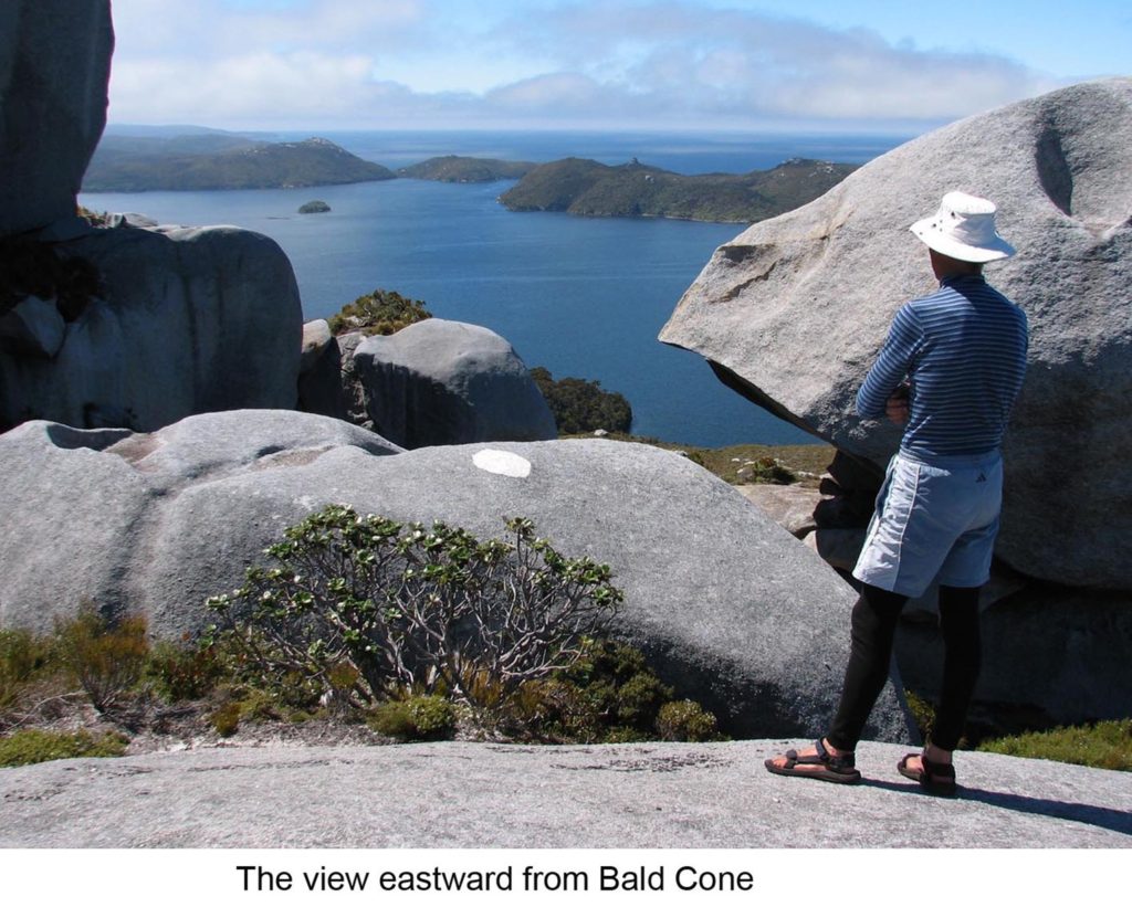
Bald Cone (7). In my opinion this is the standout attraction in Port Pegasus. Reserve it for a blue-sky day; there’s little point in viewing the inside of a cloud. On a clear day the view from the summit must be one of New Zealand’s finest. Bald Cone is made of granite. Weathering of the summit rocks has formed a fantastic jumble of immense boulders and slabs. It’s a unique landscape, and from the top Port Pegasus is spread out like a map beneath you. The track begins in a creek on the southwest side of the hill, (that is, on the northern shore of South Arm). There’s a small inlet (marked with an asterisk on my map) which leads you to the mouths of two creeks. The western creek has a small waterfall; don’t go there. The eastern creek has the track leading up from its southern bank; a piece of rope hanging from a branch marks the beginning of the track. When I was there in February the track had been marked along its entire length with pieces of blue masking tape; they won’t last long but in any case, if you go carefully, the track should be recognizable. Approaching the summit the route follows a steep, bare rock chute. Someone has helpfully hung a rope down the chute, which makes it an easy scramble. There is said to be an alternative route up the north side of Bald Cone, from Shipbuilders Cove.
Cook Arm (8). Both reaches are very shallow at their heads. The western reach will probably give access to the Fraser Mountains (Gog, Magog and Hielanman) but I didn’t seek it.
Belltopper Falls (9). Just south of the falls is the site of a failed fish-packing plant, now marked only by a stone jetty and rusting machinery (a seawater pump)?
Campsites. In addition to those already mentioned, I could find only four locations in Port Pegasus:
Places of interest. The labyrinth of inlets within the harbour is ideal territory to explore by kayak. If the beach you are approaching is already occupied by a bull sea lion and his ladies, then you might want to reconsider visiting it. Bull sea lions have big yellow teeth, weigh up to half a tonne and the ones I met didn’t like a kayaker trespassing on their territory.
Weather reports. Forecasts for coastal areas Foveaux and Puysegeur are broadcast continuously on VHF Channel 23. Of course, the limitation with VHF is that it is line-of-sight and doesn’t penetrate into the beaches and coves where kayakers are likely to camp. There may be places in Port Pegasus where Channel 23 can be heard at sea level with a handheld radio, but I couldn’t find them. However I did succeed on hilltops; for example the on the hill behind the North Pegasus Hut, and on top of Bald Cone. Medium-wave radio signals penetrate much better than VHF, so at your campsite you might well get the coastal forecast broadcast every morning after the 4am news on Radio NZ National, (the Invercargill transmitter broadcasts on 720 kHz).
Getting to Port Pegasus. A lengthy and expensive trip, however you do it. I drove from Auckland to Bluff with my kayak on top of the car. Costs (for the return trip) were petrol $400, Cook Strait ferry $380, Foveaux Strait ferry 1 passenger $126, 1 kayak $50, lock-up car parking near the ferry terminal at Bluff about $5/day. That’s a total of about $1,000 before I even started paddling. There are several charter vessels which can take parties of kayakers from Oban to Port Pegasus; eg. Aurora Charters (Colin & Margaret Hopkins, www.auroracharters.co.nz).
Having paddled between Oban and Port Pegasus I think that’s a feasible option for competent paddlers, depending of course on the weather. There are plenty of beautiful and sheltered places to land and camp along the coast. For example, (beginning at Oban) great places to stop are Chew Tobacco Bay, Kelly’s Bay in Port Adventure, Little Kuri Bay and Big Kuri Bay. All have hunters’ huts. The only problematic stretch of coast is the 25km between Big Kuri Bay and Port Pegasus, which has no obvious landings. Paul Caffyn and Max Reynolds landed at Toitoi Bay, but that is close to Big Kuri. About mid-way along this stretch is Kopeka Island and I suspect there may be a sheltered landing behind it; I regret paddling past without checking it out. All of the headlands along this coast are subject to tidal races, but they are not severe, (the flood tide sets NE, the ebb tide SW). In fine weather there will be a cold land breeze flowing down off the hills in the early morning, then a mid-morning calm followed by a sea breeze (often fresh) beginning about noon.
Finally…….. These notes were written in 2010, and with the passage of time they will become inaccurate. If other paddlers have visited Port Pegasus since then and can contribute useful information, I would be happy to receive it (contact me) so this guide can be updated.
Port Pegasus supplementary notes
Additional information provided by Rosemary Gatland, who visited Port Pegasus with Lester Miller in February 2014.
Getting There
We used Aurora Charters to take us and our kayaks down, and they will drop you off wherever you like. The cheapest way to go is to backload in when they are going to pick up a chartered group, and vice versa on the way out. It is a 3- hour trip each way.
Camping
We camped at Bulling Bay. There is a flat area here which would hold up to four tents. There is a small stream at the end of the bay with brown tannin-stained water. While this was all right for cups of tea and cooking, it did not have the most pleasant taste when used in our water bottles, and we ended up collecting rainwater when we had the chance.
There are plenty of good camping sites if you go into the bush at the north-west end of Cook Arm, but no fresh water. The tide comes in all the way up this arm to a bank at the end, but kayaks can be got out of the water at about three different places where the bank is low. These places are marked by the rushes which grow there, and you would need to walk across them. The tide here goes out about a kilometre.
The skipper on the Aurora Charters boat took us into the entrance to Cook Arm and pointed out where there was a campsite on the northern side. However, it is necessary to land the kayaks on a rock ledge, then carry them up above the waterline. We did not actually visit the campsite, but this could be a good base to walk up to Gog and Magog from.
The South Pegasus Hunters’ Hut is not visible from the water, but has a white marker (one of the ones used to mark the sides of country roads) hanging from a tree. There is a campsite just a few metres from the hut, but there is an uphill walk on a rough track to get there, ducking under an arched rata on the way. This track would also be muddy in wet weather. This would be a good base to go up to Gog and Magog from.
Marine Forecast
This is broadcast on Channel 65 at 25 past 9 in the morning. We were not able to receive this from our campsite, but could get it once out of the mouth of the bay. However we were able to receive it a 15 minute walk up to a knoll above the campsite. There is now a route marked with pink tape to our reception point. From this knoll, we also had a view down onto Pegasus Passage, and could visually check out weather conditions on this part of the area.
Historical
About 500 metres before Belltopper Falls at the top end of the North Arm of Port Pegasus is a stone jetty. This jetty marks the site of a fishing base and freezer which operated into the 1930s. From this jetty, it is a very short walk uphill to the ruins of one of the buildings from this plant. Just be aware that this jetty is used as a landing pad from time to time by helicopters on a scenic flight around the island. Along from this jetty towards the falls is a large wheel on a concrete pillar, which my book tells me is the remains of the compressor for the fish plant. Power for this plant was provided by a small hydro-electric scheme using water flowing along a water race from the stream above the Belltopper falls.
Directly across the water from the jetty is the site of the hotel and store set up for the tin mining which went on in the area in the late 1800s.
Sea lions
Before going down to Port Pegasus, we were given a briefing on sea lions by a local kayaker, who said that we will see them. He said that the females and the older males were not a problem, but that the 2 to 3 year old males could be aggressive. His suggestions were that if we were approached while we were on the water, we should close up and keep paddling. On shore, if one was getting aggressive, he said not to run away, but to stand and look big, maybe by holding the paddle up.
Sea lions are likely to be on any of the sandy beaches, or may have gone up into the bush. When approaching a beach to land, it may be possible to see marks in the sand if any sea lions are there. We were told that if we absolutely need to land, and there is a sea lion there, to go ahead and do so. He also said that it has not been known for a sea lion to actually attack a kayak or a paddler.
Our experiences with sea lions were:-
1) On one occasion we were followed in our kayaks for several hundred metres by a sea lion which was not at all aggressive, and finally diappeared.
2) On three other occasions when we were paddling, sea lions appeared but only stayed with us for short periods. None were aggressive.
3) A sea lion appeared at out campsite, looking as though he would like to come up onto the flat area where our tents were. Apart from barking once, he just looked at us for several minutes while we were standing looking at him, before turning and going away.
Get in touch
For specific enquiries, contact the relevant committee member/s on the list below.
Written correspondence
P.O. Box 9271 Newmarket, Auckland.